


 The vacant land on the corner of Stanley St and Pertobe Rd, Warrnambool, which is now before council seeking approval for an eight-lot subdivision.
[dropcap style=”font-size: 60px; color: #5C747D;”] P [/dropcap]rominent Warrnambool lawyer James Tait has lodged fresh plans to Warrnambool City Council to subdivide one of the most prominent pieces of vacant land in the city on the corner of Pertobe Road and Stanley St, South Warrnambool, overlooking the Merri River.
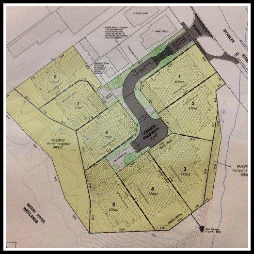
Mr Tait, via his company NFM Nominees, is intending to subdivide the .73 ha lot into eight – yes, eight – blocks sized between 512sq/m and 692 sq/m, with a cul-de-sac up the centre.
[box]YOU CAN VIEW/DOWNLOAD THE LAND MANAGEMENT PLAN HERE AND THE FULL APPLICATION HERE (each file is a pdf about 3mb)[/box]
It is the second time Mr Tait has attempted to gain planning approval for what is almost certain to be a subdivision that generates a lot of discussion, especially among those who would prefer to see this rare slice of vacant river land remain just that, vacant, or at least with less blocks.

The .73ha site would include .12ha set aside as a conservation reserve, with a 1.2m cyclone fence to be built to keep out the public (and presumably those who will eventually live in the eight dwellings to be later built on site). A further 1000 sq/m of flood prone land on the southern side will be donated to the council as a reserve.
Any houses, by the way, will be subject to separate planning approvals. The application now before council is purely for the subdivision.
“…(this) is considered to represent an excellent subdivision outcome for this land and surroundings,” is how it was described in a letter to council by Brendan Howard, a former council planner, now from Urbanomics, who has prepared the application for NFM Nominees. (*note, an earlier version of this piece incorrectly attributed this quote to WCC planner Kirsty Miller. We apologise for that error).
 The proposed eight-lot subdivision at the corner of Stanley St and Pertobe Rd, South Warrnambool.
[dropcap style=”font-size: 60px; color: #5C747D;”] S [/dropcap]o what are the environmental implications of such a subdivision on a prime coastal site?
We aren’t experts, but according to the environmental assessment on behalf of NFM Nominees, the “near threatened” Latham’s Snipe has been spotted on the site and the adjacent estuarian wetland.
This is the same bird that eventually scaled right back the development of land next to the Powling St wetlands in Port Fairy, although it was found in much larger numbers at that site. (See our earlier story on that lengthy battle here.)
It is also an ideal environment for the critically endangered Orange Bellied Parrot, although the report does not say if any have been found there.
Overall, however, the environmental assessment concluded that the majority of the Stanley St land was covered in introduced vegetation, and only .106ha of native vegetation would need to be removed for the subdivision.
With the towering Lady Bay motel development diagonally across from this last remnant of vacant land, it appears the high-density development of this area of South Warrnambool is set to continue.
Submissions on the subdivision plan close on December 11.
This is nuts. Last year with the king tide swell, South warrnambool kinder was evacuated as the merri lapped into the kinders playground. Again this year, I’ve observed the river rise way up over the banks. It’s a flood zone!
This morning my 5 year old and I counted pelican’s, ducks and a host of wildlife as we crossed the bridge from kinder. It should be a protected area held valuable by our community. I often stand on the bridge and admire the view, with my hand shielding the playschool windows of the Lady Bay. It’s a wonderful, wild place and I can only hope that WCC rejects this bid. It’d be another tragic development.
Thanks Bluestone. I’ll look into it.
Thanks for bringing the application to our attention, but I don’t agree about any development is bad development. Does a minimum block size of 512m really constitute high density development?
I’d like to see some more conservation area designated along the top of the bank facing the Merri to create a larger buffer, but the fence to prevent residents wandering out onto the wetlands seems ok to me. If it were to keep people out, then those people would have been in the wetlands walking on the habitat…
As private land, it’s inevitable it will be built on. Reasonably sized residential lots is certainly not the worst case scenario here; that would be in the view of the blocks facing across the river!
Thanks for the comment Sam and you are right, not all development is bad development and 512 sq/m blocks are not tiny, but I think the main issue is the location right on the edge of the Merri estuarine area. Eight (most likely two-storey) dwellings is sure to have a significant visual impact on what is such a high-profile and lovely area.
I must confess that I didn’t even know this was private land until recently – I always thought it was part of the open space around the Merri river/Edwards Bridge.
I have since been told it was originally two titles, but which is set to become eight, which I guess is an indication of the changing times around how we do housing where the emphasis appears to be on fitting as many dwellings as you can onto a piece of land – even one as rare as this one.
No doubt the discussion will continue!